The San Francisco Bay Area is an extensive region that surrounds the San Francisco and San Pablo estuaries in Northern California. Before Doomsday, it included the major cities of San Francisco, San Jose and Oakland, and dozens of other cities, towns and communities. The population of the nine-county area (incorporating San Francisco, San Mateo, Santa Clara, Alameda, Contra Costa, Solano, Sonoma, Napa and Marin Counties) was recorded as 5,179,784 in the 1980 US census and was estimated to be around 5.4 million in 1983. The area suffered catastrophic damage during the events of Doomsday, and its current population is estimated at less than 200,000 people.
Along with the rest of the Americas, California was settled prior to 10,000 BC by prehistoric peoples crossing
Map of tribal divisions and estuaries in the Bay Area prior to large-scale irrigation projects. The map is also a roughly accurate guide to the present hydrological state of the Bay Area.
over from Asia via the Bering land bridge. By the end of the 15th century CE, dozens of small cultural groups had established themselves in the hills, valleys and wetlands surrounding San Francisco Bay.
Although Spanish and English vessels had navigated up and down the California coast since Juan Rodriguez Cabrillo's pioneering voyage in 1542, unfavorable currents and persistent fogs hid the narrow entrance to the bay from ships for over two centuries. It remained unknown to Europeans until a Spanish overland expedition led by Gaspar de Portolá encountered it in 1769. Juan de Ayala was the first European to sail through the Golden Gate (named in 1846 after the similarly arranged harbor of Byzantium which was known as Chrysoceras, or "the Golden Horn") on August 5th, 1775, and Spanish colonization followed soon afterwards in order to forestall English and Russian incursions from the north.
When Mexico won its independence from Spain in 1821, possession of the Bay Area devolved to the newborn country. The local economy was based on farming, cattle and the fur trade, and it remained so through 1848, when California was taken over by the United States after the US-Mexican War. In the same year, however, gold was discovered in the Sierra Nevada, and San Francisco rapidly became a destination for thousands of immigrants attempting to find their fortune in the mountains to the city's east. Most failed at that aim, but many of those who remained found wealth in farming, lumber or other industries and formed the core of a mushrooming economy that propelled the state into the Industrial Age. The Great Earthquake and Fire of 1906 destroyed most of "Babylon-By-The-Bay", but ultimately the residents rebuilt their city and spread its urban dynamics across the rest of the Bay Area.
Before Doomsday, San Francisco was considered the cultural and financial center of Northern California and a world-class tourist destination. To the south, the Santa Clara Valley (including San Jose and its surrounding cities) became known as "Silicon Valley" due to its prominence in the burgeoning computer industry, and some predicted San Jose would pass San Francisco as the most populous city in the Bay Area by 1990. Oakland was a major shipping port, the western terminus of the Union Pacific Railroad, and a significant distribution and manufacturing center. Overall the Bay Area was known for its natural beauty, affluence, high levels of education and cultural diversity. Unfortunately, it also hosted a number of military and industrial facilities that were prime targets for Soviet nuclear forces.
Doomsday[]
On the early evening of Sunday, September 25th, 1983, the major freeways in the area were relatively busy as motorists departed from the Niners-Falcons NFL game at Candlestick Park and returned from weekend getaways to other parts of the state. The 35th Annual Primetime Emmy Awards were taking place to the south in Los Angeles, but NBC planned to air a tape-delayed broadcast in the Pacific Time Zone at 8:00 PM. The local TV stations were playing local programming, syndicated shows or national network news programs.
At 5:52 PM PDT all TV and radio programming was interrupted by break-ins from the networks and the Emergency Broadcast System announcing the impending Soviet attack. The mayors of San Francisco, Oakland and San Jose (Dianne Feinstein, Lionel Wilson and Tom McEnery, respectively) immediately ordered the evacuation of fire, police and medical units from their respective city centers, but emergency personnel were able to make little headway against the throngs of cars and panicked citizens that quickly filled the streets.
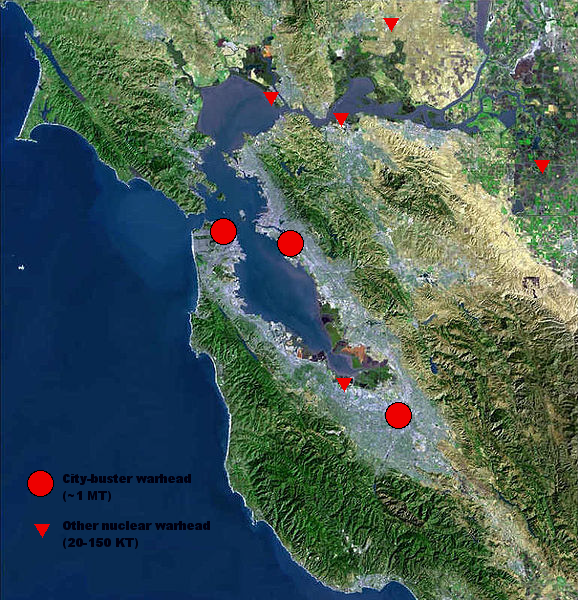
The first nuclear detonation occurred at 6:11 PM above Travis Air Force Base, just outside of Fairfield in Solano County; although the explosion was centered on a relatively remote area, it was visible across much of the Bay Area and served to magnify the chaos and terror that engulfed it. Six additional warheads (including three multi-megaton "city-busters") reached their targets over the next 20 minutes.
Targeted areas/Impact Sites[]
Impact sites have been reconstructed from eyewitness reports of survivors, blast patterns noted from later aerial observation, and Warsaw Pact target lists acquired by Western intelligence before or after Doomsday.
Downtown San Francisco (targeted by city-buster)
Downtown Oakland/Port of Oakland/Alameda NAS (
Impact sites in the San Francisco Bay Area on Doomsday; the impact site on the upper right edge of the map is Stockton, which is not generally considered part of the Bay Area but is included on this map.
targeted by city-buster)
Downtown San Jose (targeted by city-buster)
Travis Air Force Base, Fairfield
Concord Naval Weapons Station, Concord
Mare Island Naval Shipyard, Vallejo
Moffett Naval Air Station/Air Force Satellite Control Facility, Mountain View/Sunnyvale
After Doomsday[]
Some areas were relatively unscathed by the initial attacks - the middle portion of the San Mateo Peninsula, the I-680 corridor between Dublin and Walnut Creek, and the cities of Marin, Sonoma and Napa Counties in the North Bay being the most significant. However, most residents of these areas were cut off from escape due to the destruction or blockage of nearly every major freeway in the area and the jamming of the surviving roads by desperate survivors. This and the failure of water and power systems left them extremely vulnerable to the secondary effect of the attack - massive firestorms ignited by the thermal pulses of the detonating nuclear weapons. In late September the area was at the end of the annual summer dry period, and the parched grasses and trees of the hills fueled a second round of uncontrolled fires that devastated whatever had survived the initial urban conflagrations. Survivors that escaped the area reported "avalanches of flame" sweeping through entire communities behind them, and although the first rains of fall helped quell the inferno five days later, periodic clouds of ash and smoke were visible from as far off as central Nevada well into November.
There were still many survivors, and the state government attempted to provide aid and maintain governance from its relocation site in Placerville, but as its own overstretched resources dwindled its efforts inevitably faltered. After three separate convoys of medical supplies were ambushed and looted in the spring of 1985, regular contact with the area ended. Sporadic radio broadcasts were detected from survivalists and other parties that claimed to be hiding out in various mountain locations, but the last such transmission ("La Honda Lily's Big F*** the World And My Lung Cancer Broadcast") was recorded in November 1987. Seismometers across the world detected a magnitude 7.1 earthquake centered approximately 50 miles south of San Francisco in October 17, 1989. When eventually queried by ANZC geologists, residents of nearby survivor states confirmed a "long roller" (indicating a powerful earthquake some distance away) was felt in those areas around that time.
The Benjamin Franklin and the Commonwealth[]
The USS BenjaminFranklin reached the Bay in June 1991 during its first reconnaissance voyage out of Australia. Observations of inland areas were difficult due to heavy fog, but the crew noted the coastal forests were starting to regenerate and were also able to identify the burnt-out remains of Pacifica and Daly City to the south of the Golden Gate. Thin pillars of smoke issuing from the Lake Merced area on the southwest edge of San Francisco's city limits pointed to an active human presence; this made sense as distance and terrain would have protected that area from the worst of the city-buster's effects. A landing party found only a rough circle of hastily abandoned huts constructed on a golf course from the remnants of nearby buildings; it appeared the occupants had retreated inland. The party left care packages that included technical knowledge, medical supplies and information about the present state of the world, and returned to the Franklin.
The Franklin was blocked from entering the Bay itself by the collapsed Golden Gate Bridge. The next day, five volunteers set out in a pair of inflatable boats and carefully navigated through the rusting remains of the bridge into the Bay proper. They confirmed that nothing remained of downtown San Francisco, Oakland and Treasure Island (all mostly built on landfill) but mud flats, charred rubble and open water. A single half-melted support tower from the eastern truss span was all that was left of the Bay Bridge, but oddly enough the old federal prison on Alcatraz Island (just two miles off Fisherman's Wharf) was mostly intact. To the south, Candlestick Park had been pancaked into a mass of broken concrete and steel. The San Mateo Bridge was still visible in the distance, but surviving buildings on both sides of the Bay's interior shoreline appeared to be partially submerged.
The water inside the Bay was foul-smelling and discolored; later testing indicated heavy radioactive and chemical contamination from toxins leached out of the ruined cities by rainwater. The explorers turned north to investigate the bayshore north of Oakland, but their mission was cut short when one of their number was wounded by sniper fire from an unknown party as they attempted to land at the partially intact Berkeley Yacht Harbor. They withdrew to the Franklin (where they were decontaminated and the injured sailor was successfully treated for a single .22 rifle bullet wound to the left shoulder), and the submarine's captain decided to make no further investigations into the bay.
The next major visit from overseas came in 2000, when the flotilla headed by the ANZS Commonwealth (formerly USS Carl Vinson) took station west of the Farallon Islands. The coast was again obscured by fog, but the Commonwealth carried several squadrons of helicopters and scout planes that took recce, research and medical teams as far inland as Ukiah and Lake Sacramento over a period of three weeks. The results of these probes were mixed; scattered hamlets of survivors were found in many locations, but their universal response was either to flee, or to attack without provocation with whatever weapons were at their disposal (later encounters by the ANZC teams with roving biker gangs and a well-armed slaving party from Santa Cruz made their reaction to large groups of armed strangers understandable). Larger, more organized settlements were found in the less heavily damaged North Bay, but their reactions were similar. In total, the clashes resulted in eight casualties to ANZC troops (including two deaths) versus an estimate of at least 200 for the various opposing forces.
The Commonwealth's Cultural and Technological Recovery Teams (known to the crew as "CaRTs and TaRTs") had great success in rescuing knowledge and artifacts from museums, universities and other intact locations. Some of their notable discoveries include:
Data and equipment from numerous high-tech companies, including blueprints of the Intel Corporation's prototype "386" chip architecture and irreplaceable parts and supplies for semiconductor fabrication facilities.
A cache of historic films found in the burnt-out remnants of George Lucas's Skywalker Ranch. The cache included a rough cut of the unreleased sequel to Steven Spielberg's Raiders of the Lost Ark, which was eventually restored and exhibited in 2005 as Indiana Jones and the Stones of Sankara.
Much of the data and seed bank reserves of the agricultural research facilities at the University of California, Davis. Possibly the most significant achievement of the teams, these discoveries proved invaluable in the worldwide fight against hunger over the next decade.
A single "Midnight" team (composed entirely of former United States military personnel) was sent on classified missions to the sites of the Lawrence Livermore and Sandia National Laboratories, the USAF Satellite Control Facility in Sunnyvale and the Naval Communication Station at Stockton. The CRT/TRT teams were widely publicized in the ANZC media (with two feature films and the popular TV series Diggers being produced about them), but later on they would become points of contention with the California Republic, who considered their mission akin to an act of piracy against the heritage of the state.
After the Commonwealth reported its findings back to Canberra, the ANZC government and its advisors from the former American Provisional Authority judged resettlement of the Bay Area to be impractical. The hostility of the locals, the damage to the environment and the local infrastructure, and the extreme distance from the nearest ANZC-associated territory (the Free State of Hawaii) were not utterly insurmountable, but the new country's limited resources were stretched thin as it was without the additional burden of rebuilding society an ocean's width away. Reconstruction would have to wait for the ANZC economy to grow to a point where it could take on the job (which would take until at least 2050 by best estimates), or for another government to take control of the area.
The California Republic[]
The second condition manifested itself in June 2007, when a task force from the reconstituted California Republic crossed Putah Creek into Solano County. Numerous scouting missions into the Bay had been sent prior to the start of "Operation Emperor Norton", and the expedition was well-prepared for the task ahead. The combined force of three CNG combat battalions, a good proportion of the Republic's existing heavy construction equipment, and a labor corvée of prisoners working toward reduced sentences established a chain of fortified bases at Dixon, Vacaville and Fairfield. At the same time, they cleared Interstate 80 of abandoned vehicles, repaired or bypassed damaged sections of the roadway (mostly in Fairfield, which was only five miles west of the Travis AFB impact site), defended against intermittent attacks from bandits and paranoid local residents, and accepted requests for aid or citizenship from those who came in peace. The force reached Vallejo in early October, just in time to settle in for the onset of the rainy season, and the city was officially annexed into the Republic on New Year's Day 2008.
Most of the next two years were spent preparing Vallejo and the adjacent Mare Island Naval Shipyard for reoccupation, and reconnoitering sites for a naval base to maintain watch over the Golden Gate. Ultimately the Tiburon Peninsula was chosen as "the best of a bad lot"; although somewhat damaged on Doomsday, its position and isolation protected it from overland attack and gave it an excellent vantage point over any ships attempting to enter the northern reaches of the Bay. Fortifications on Tiburon and nearby Angel Island were established in late 2008 and have been continually reinforced up to the present day.
The wreckage of the southern half of the Golden Gate Bridge was finally cleared in 2010, allowing larger ships to safely make their way into the Bay. As it stands, the Republic's plans for the area in 2011-12 include the settlement of the Hercules and Rodeo areas across the Carquinez Strait from Vallejo, re-establishment of farming in the still-productive parts of the Davis-Vallejo corridor, and a systematic census of the remaining population and infrastructure in the Bay Area to aid in the planning of future projects.
The Present[]
After the Franklin and Commonwealth expeditions, overflights from Mexico, the ANZC and the North American survivor states have combined with first-hand accounts from overland scouts and the California Republic's reclamation program to produce a clearer picture of the state of the Bay Area. The flow of water into the area from the Sacramento River and other watersheds has increased due to weather pattern changes and the end of industrialized farming. In addition, the pumping out of groundwater from local wells has ceased; the net result is that most of the river valleys and shore areas have reverted to the wetlands and marshes they were before large-scale water projects were initiated in the late 19th century. Many river valleys now essentially become lakes during the rainy winter and spring, and the surface area of the Bay has grown dramatically as areas of burnt-out landfill (and, in the case of Foster City, an entire municipality) have sank or eroded away.
Due to the rising water table, lingering contamination and the destruction of the local highway system, much of the bayshore and valley areas are cut off from the rest of the state and remain sparsely populated at best. Flyovers have revealed scorched and sodden ruins similar to what the Franklin's volunteers saw in '91 but with the addition of two decades of plant growth; new stands of live oak, madrone and buckeye now dot the grassy fields that were once housing developments and shopping malls. Local wildlife such as deer, wildcats and feral cattle have adapted to the conditions with gusto and are common sights on what remains of area streets. Several pilots have claimed to have seen elephants, African lions and other exotic animals that would have escaped from the Marine World Africa wild animal park in Redwood City, but no photographic confirmation exists as of yet.
File picture of halophilic algae (ca. 1982). By now the mutated version found in "pink water" has escaped its containment ponds and covered the entire water surface visible in this picture.
Of greater concern to ecologists than the possibility of introduced megafauna is the unmistakable pink tinge that has slowly spread to cover the southern half of the Bay. Analysis indicates the color change is caused by a mutant species of halophilic (salt-loving) algae that originated in the hypersaline salt extraction ponds north of San Jose. The environmental changes after Doomsday seem to have triggered rapid evolution in those algae, allowing them to spread out to the less salty waters of the Bay proper. "Pink water" has neurotoxic and allergenic properties when consumed or even touched and poses a potentially worldwide threat if transplanted to other regions. Consequentially, the California Republic has banned ships with bilge tanks from traveling south of the ruins of the Bay Bridge and is considering mandatory inspection of all boats that cross that line.
Despite the destruction, human survival and even civilization had continued in the upland portions of the area, and the California Republic is making a concerted effort to assert its control over what remains. But given the residual radioactive and chemical pollution and the devastation of local infrastructure, it will be many decades, if not centuries, before the area is restored to a semblance of its further greatness.
Notable Sub-Regions[]
San Ramon Valley[]
This inland valley was completely isolated by the destruction of Walnut Creek, Livermore, and Fremont and then overwhelmed by firestorms over the succeeding days. The plant life on the hillsides has mostly recovered after the passing decades, presenting a deceptively tranquil face to any visitors. The major remaining evidence of human civilization is the remnants of Interstate 680 that followed the valley from north to south. The parts of the freeway that did not collapse or ignite after the fires swept over them are surmounted by thousands of burnt-out vehicles and, chillingly, the carbonized remains of those who tried to escape the firestorms by climbing onto the semi-molten asphalt. The entire area is considered unlucky by the few nearby residents and thoroughly avoided (although not that many people dare approach the radioactive rubble situated at the approaches to the area in the first place).
Brentwood/Discovery Bay[]
These suburban cities was not directly hit during Doomsday, but the same firestorms that wiped out the cities to the west tore through their streets on their way to the Sacramento/San Joaquin Delta on the east. Fortunately the relatively open terrain allowed survivors to escape more easily (although many drowned attempting to cross the nearby sloughs and marshes), but the area has not been reoccupied except for small bands of miners that work the low-quality coal and sand seams to be found under Mount Diablo to the west.
The Napa Valley Padrones[]
The major cities of the Napa Valley (American Canyon, Napa, Yountville, St. Helena and Calistoga) weathered both the immediate attack and the subsequent firestorms and fallout, but the area was left with few resources and little social cohesion. Ultimately, a coalition of local landowners established a quasi-feudalistic patronage system, with the majority of the populace working as "bonded citizens" (serfs in all but name) on the former vineyards owned by the wealthy oligarchy. This system deviates widely from the standards set by the original US Constitution, but it is distinct from the outright slavery and despotism practiced by Santa Cruz and other regimes; for example, BCs who possess sufficient wealth or talent can improve their station, and a good number have married into or been adopted by the "Elite Eight" families. Relations with the California Republic have remained peaceful even after their annexation of Vallejo (just across the Highway 29 line that serves as the de facto southern border of Padrone lands), but the Padrones have steadfastly resisted any agreement even hinting at political union with the Republic. Currently (2011) negotiations are still ongoing for allowing the Republic to use the blocked-off Napa County Airport as an emergency landing strip.
Vallejo[]
The nuclear warhead targeted at the adjacent Mare Island Naval Shipyard detonated at an unusually low altitude (ca. 50-100 meters instead of the usual 500-1000), leaving the adjacent city of Vallejo relatively intact. However, fallout from the impact and the failure of utilities and food distribution quickly forced the population out. After the California Republic claimed the area in 2008, workers (as with Operation Emperor Norton, mostly convicts) were housed at the less damaged southern end of Mare Island and shuttled over daily by boat to repair and rebuild the city proper. The city was pronounced open to resettlement in 2009, and the few thousand Republic citizens living there now are mostly involved in exploration, handling the slowly increasing ship trade coming into the Bay, and trade and negotiation with the Napa Padrones to the north.
Tiburon[]
Unlike Vallejo, this upscale community suffered significant prompt damage from the San Francisco city-buster when it detonated only eight miles away. The California Republic's original intent was to use Tiburon as a temporary base to clear the wreckage of the Golden Gate Bridge out of the Bay's mouth before fortifying it, but as the magnitude of that task became clear their government decided to fully establish a settlement before starting work on removing the thousands of tons of fallen steel that blocked the harbor. With the removal work finally completed in late 2010, the resettled town and the CCSG base on nearby Angel Island now handle customs and inspections for the increasing number of trade ships that arrive at the Bay from Chumash, the MSP and points beyond. Because of Republic security concerns and toxic and radioactive pollution from the Concord warhead and the burnt-out refineries on the southern shore, navigation beyond the Carquinez Strait is prohibited. Instead, incoming ships have their cargo transferred to Republic barges which take it to Vallejo, from there, mule teams and the occasional bio-fuel powered truck send it up the rebuilt Highway 80 to Davis and the Republic proper. In addition, the CCSG guards against any attempts by Santa Cruz or other hostile forces to penetrate the inland waterways by sea.
West Marin Alliance[]
Only the southern half of Marin County was directly affected by the warheads of Doomsday, but the uncontrolled fires that started there were enough to burn out much of the US 101 corridor between Mill Valley and Novato. Across Mt. Tamalpais to the west, though, the rural western half of the county was able to fight off the blazes but found itself effectively cut off from the rest of the area. Since then, the towns of Inverness, Point Reyes Station, Olema and Bolinas have remained linked by State Highway 1 and have maintained a semblance of the traditional industries of dairy farming, fishing and oyster harvesting from before the war. After raids from biker gangs and Santa Cruz slavers began to pick up in the mid-1990s, a regional militia was established that patrols the area constantly, but the residents have avoided any kind of centralized government beyond a mutual defense association, a volunteer fire brigade, and local town councils. The few visitors (including members of the recce teams from the Commonwealth in 2000) are warned away from Point Reyes Peninsula to the west by tales of vicious cannibal bands (similar to the legendary Sawney Beane clan of Scotland) that stalk its fogbound shores and snare unwary travelers; it's uncertain whether these rumors have basis in fact or were created by local residents to keep potential spies away.
Petaluma[]
Isolated by the destruction of the cities to its north and south (Santa Rosa and Novato by plague/famine and fire, respectively), Petaluma endured the same degeneration into anarchy and chaos as many other surviving American cities did. Until recently, the area was under the "control" of a shifting network of minor cults, militias, street gangs and soldiers for hire; after the takeover of Bodega Bay by Santa Cruz forces in 2002, the forces formed a loosely united front against the well-armed newcomers but were slowly eroded by periodic slave raids and the occasional all-out assault. In the past few years, however, much of the city has come under the control of an apocalyptic cult known as the Church of the Fiery Carousel. This syncretic religion is led by a mysterious, messianic figure known only as "The Sanguine" and appears to have melded elements from multiple belief systems (both familiar and esoteric) into a potent mix of fanaticism and martial prowess. Following the "Red Green Day" (the 2009 spring solstice, when the flayed bodies of nine Santa Cruz subcommanders were found arranged in an anagram outside the old Phoenix Theater), the CFC quickly gained adherents and succeeded in pushing the slavers' forces as far back as Penngrove. Both the Napa Padrones and the administrators of the California Republic's new holdings in Vallejo have begun to take note of activities there, since they are both logical targets for the CFC if its followers turn from self-defense to expansionism.
Bodega Bay[]
This former resort town was shielded from much of the chaos following Doomsday by its remote location and the plague-ridden ruins of Santa Rosa, but these same factors combined with food shortages and demographics skewed toward retirees to cause a slow but irreversible drop in population. After 1990 the city was essentially abandoned (and reported as such by the Franklin expedition) until a seaborne expedition from Santa Cruz occupied it in 2002 in an attempt to outflank the West Marin Alliance and establish a base closer to the northern city-states that would later form the MSP. However, efforts to expand beyond the city limits have been stymied by the numerous biker gangs to the north, the stalwart resistance of the West Marin Alliance to the south and (more recently) the fanaticism of the Church of the Fiery Carousel in Petaluma to the east. Current scouting reports describe it, to quote an old film, as "a wretched hive of scum and villainy".
Alcatraz Island[]
As reported by the Franklin, most of the stoutly constructed buildings (with the exception of the lighthouse and water tower) survived Doomsday. In the following decades, several parties attempted to set up colonies there; at least two of them deliberately echoed the occupation of the island by Native American activists in 1969-71. Unfortunately, fallout from the city-busters and the still-toxic waters of the Bay have rendered the island lethal for long-term settlement. The most recent attempt was made by a group of approximately 25-30 people in the summer of 2003. The next spring, a West Marin coastal watcher saw a battered rowboat wash ashore onto Muir Beach. Inside was an unconscious, clearly sick young woman clutching a dead infant. She was taken to Bolinas Community Hospital, where the doctor on duty determined she was suffering from a combination of malnutrition, organometallic poisoning and radiation-induced immune system failure. She died without regaining consciousness, but markings on the rowboat indicated it came from the National Park Service facilities on Alcatraz. The California Republic has declared the island off-limits and sends periodic patrols ashore (clad in hostile environment suits) to ensure that no more illicit settlement occurs.
Lake Merced[]
The hamlet encountered by the Franklin has grown over the years into a small town known locally as Mercyport. Ocean fishing, whaling and trade with the occasional sailing vessel are the primary industries, and the residents voyage to the Farallon Islands from time to time to hunt seals and collect eggs from the nests of waterbirds, just as San Franciscans did in the Gold Rush days. They remain wary of slaver raids from Santa Cruz, and they are proficient in retreating up well-fortified Mount Sutro to the northeast in times of trouble. Unfortunately, this well-founded paranoia has prevented any meaningful diplomatic exchanges with nonbelligerent parties (such as the California Republic and the MSP) at this time.
Mid-Peninsula[]
The part of the San Mateo Peninsula ranging roughly between the San Mateo and Dumbarton Bridges were not directly targeted during Doomsday, but the impacts at SFO and Moffett Field (both next to Interstate 101), and miles-long traffic jams of fleeing vehicles on the above-mentioned bridges and Interstate 280 cut off most escape routes. Although most of the bayshore communities east of Highway 101 have ended up underwater, sufficient land exists further west to maintain a decent-sized population. However, the isolation of the area has made it difficult to judge how many people are actually there. The Commonwealth's TRT-5 found a fairly large community clustered around its investigation site at Stanford University in 2000, but unexpected resistance in the form of automatic weapons fire drove them away before the could land their helicopters. Landings further north found recently abandoned residences similar to those seen by the Franklin at Mercyport nine years earlier. The Stanford community might be based around former National Guard, ROTC or Army elements, or a faction of the Santa Cruz slavers, but their persistent belligerence and the increasing presence of "pink water" in the southern Bay has made further investigation impossible at this time.
Morgan Hill/Gilroy/Hollister[]
Although the agricultural towns of southern Santa Clara and San Benito Counties were starting to transition from farming communities to residential suburbs, at the time of Doomsday they were considered peripheral to the Bay Area at best. They were not directly targeted by the attack, but they all suffered through the usual post-Doomsday tribulations of plague, starvation and civil conflict. As Santa Cruz flexed its muscles in the mid-1990s under the Scholairi regime, the residents of the region were almost eager to submit in order to gain protection from the various bandits and malefactors that tore through the countryside. So far, their situation has improved only slightly; although the area currently styles itself the "South Valley Republic", the farmers remain in thrall to their masters to the west as a ready source of food and slaves (not interchangeably - despite rumors the Santa Cruz slavers are not cannibals unless they are trying to make a point), and as a buffer from the gangs and warlords of the Central Valley.


