| |||||
| Capital (and largest city) |
Sanniquellie | ||||
| Language official |
English | ||||
| others | Many native languages | ||||
| Religion | Christian, some animist and Muslim | ||||
| Government | Presidential Republic (once elected) | ||||
| Area | Approx 42,000 (From 2013), 67,000 (From 2014) km² | ||||
| Population | Approx 470,000 (From 2013), 545,000 (From 2014) | ||||
| Established | Agreement signed 2011, will come into effect 1st Jan 2013. | ||||
| Currency | West African Franc | ||||


Founding Nations of the Federation
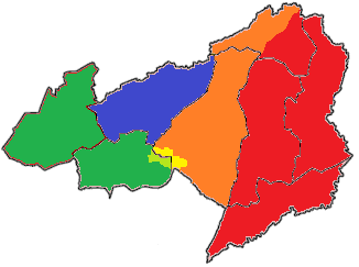
- Nimba (Red on Map)
- Democratic Republic of Liberia (Yellow on Map)
Future Member of the Federation
- Lofa - applied 2012, joining 1st of January 2014. (Blue on Map)
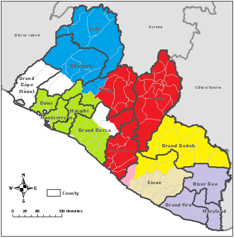
In addition an area of Sinoe County is administered by Nimba (Pink on the Map) and DRL (Brown on Map).
On the 1st January 2013 the administration of this area will transfer to the Federation of Liberia, this area will join the Federation fully at the same time as Lofa
History of the Federation[]
Pre-Federation history of Liberia: Liberia
With help from the West African Union, and in particular the WAU nations that share a border with the prospective Federation (namely the Republic of Guinea and Ivory Coast), talks began in 2010 to unite the Democratic Republic of Liberia and the Nimba into a Federation of Liberia.
Both nations agreed to the deal put on the table by the WAU and signed the Federal Agreement on the 31st of December 2011, the new nation of the Federation of Liberia (will probably be known as Liberia for short) will come into effect on the 1st January 2013. With a centralised government based in the Nimban capital of Sanniquellie.
At the same meeting they two nations decide on a new flag, based on the old Liberian flag they keep the blue quarter canton with a white star to represent freedom in the Federation of Liberia, they do however replace the white stripes with green stripes to represent the land of the Federation of Liberia and made the red stripes brighter to represent the blood of the people of the Federation of Liberia.
From the 1st February 2012 the armies of Nimba and the Democratic Republic of Liberia merged into a newly formed Federation Army.
In early 2012, with help from West African Union troops the nations that will make up the Federation of Liberia took control of the remainder of the former Liberian Grand Gedeh County. It was found to be relatively easy, as they are members of the same tribe (Krahn) as one of the founding members of the Federation, the Democratic Republic of Liberia. In the south of the county the local population had been suffering cross border raids from the RRL so welcomed the Federation/WAU troops with open arms.
Application to Join[]
In February 2012 the Democratic Republic of Lofa applied for membership in the Federation. After discussions between the governments of the two founding members of the Federation and representatives of the WAU the application was accepted, Lofa will join the Federation on the 1st January 2014, two years after the foundation of the Federation.
Due to the successful application of Lofa, there are plans for the new Federation (with the help of the WAU troops) took the unclaimed land in Bong County, which is located between the two nations in May 2012.
First Federal Election[]
The first federal general election will take place in Nimba and the DRL on the 21st June 2012, the results will be announced on the 29th June 2012 with the new government formed in October 2012.
The election was run by WAU officials to allow to to be free and fair.
The New President of the Federation of Liberia was be announced at the same time as the election results.
President of the Federation of Liberia[]
The first President of the Federation of Liberia has been named as Moses Quincy Fofana, born in Sanniquellie 1968. He was formally the Trade and Industry Minister for the Republic of Nimba.
Government of the Federation[]
The Federal Assembly is currently be made up of 150 members.
Another 80 members will expand the Assembly when Lofa and remainder of Sinoe County joins in 2014
2012 Federation Land Acquisition[]
As planned, WAU and Federation troops have begun to take the uncontrolled section of Grand Gedah County.
All land taken will be incorporated into the Democratic Republic of Liberia until the Federation of Liberia comes into effect on the 1st January 2013, at which point it will be included into the Federation.
Grand Gedah County[]
22nd March
At 10am on the 22nd March 2012, 1000 Ivorian troops, 1000 Guinean troops and 1500 troops from the Federation of Liberia cross into the uncontrolled section of Grand Gedah County.
Ivorian troops cross into the uncontrolled territory from two points, one group of 500 troops from the Ivorian town of Nigra and another 500 troops from the Ivorian town of Pauleoula.
Guinean troops, along with the Federation troops cross into uncontrolled territory at four points along the Federation border, roughly 620 troops cross at each point.
A WAU military official has said he expects Grand Gedah County to be under total WAU/Federation control by the end of March, and fully democratic by June 2012.
23rd March
Ivorian troops have made very good progress into the unclaimed territory taking an average 25 miles from the border with Ivory Coast, they have been ordered to not get within 10 miles of the Revolutionary Republic of Liberia border, with the hope that this distance will stop a possible retaliatory attack from RRL troops.
The Guinean/Federation troops have made slightly less progress with only 10 miles of territory taken.
WAU military officials have said that there is only approximately 35 miles of uncontrolled territory between the WAU/Federation troops.
24th March
The Ivorian troops have slowed their advance to give them time to rest from the advancements of the past two days. They still take five miles of uncontrolled territory. At the same time the leaders of the Ivorian troops has been in trade talks with village and tribal leaders in the 10 mile wide area of south of Grand Gedah County that they have been ordered not to enter as it is too near RRL territory.
The Guinean/ Federation troops have made good progress taking 15 miles of uncontrolled territory.
In some places the troops are so close to each other that radio contact is possible between the two WAU troops.
25th March
In the north of Grand Gedah County the Ivorian and Guinean troops have joined up secured the counties northern border with Ivory Coast and are heading southwards towards Federation troops in the south of the county.
26th March
With the exception of a few small areas Grand Gedah County is now entirely in WAU/Federation hands. The last hold out areas are expected to be under WAU/Federation control by the 29th March.
There was no major resistance to the take over of the area, the townships in the south welcomed the troops as they had been suffering from raids from RRL troops.
WAU troops are in the process of setting up border protection points roughly ten miles north of the RRL border.

After the success of the taking of the remainder of Grand Gedah county, further land acquisition, with help of the WAU troops, may take place this year in the area around soon-to-be Federation territory.
The expected targets are the remainders of Grand Bassa or Bong Counties.
29th March
On the 29th March, a joint WAU/Federation conference announces that the next section of uncontrolled land to be taken for the Federation will be the remainder of uncontrolled Bong County. This is expect to occur sometime in May 2012. The section designated for acquisition are Suakoko and Zota Districts.
In order for this to take place the Guinean troops will be withdrawn from Grand Gedah County to assist a joint Federation/WAU/Lofan force. The Federation will provide 500 troops, Lofa will provide 500 troops as well as the 1000 Guinean troops.
Ivorian troops will remain in Grand Gedah County, they will man the new RRL border posts in Grand Gedah County until Federation troops are in a secure position to take them over, as well as assisting Federation troops in the repair of infrastructure in the newly acquired section of the county.
There are also talks underway with Monrovia about the remainder of Bong county (namely Fuamah and Salala Districts) as these areas have close links to Monrovia despite being in the hands of warlords.
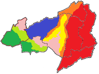
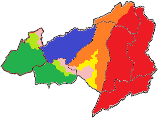
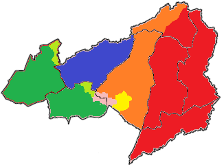
Bong County
The WAU/Federation/Lofan task forces invasion of uncontrolled sections of Bong County is now planned for mid May 2012, Monrovia has agreed to assist the WAU troops in Fuamah and Salala Districts, it is expected that Bong County will fall into controlling hands (Either Federation or Monrovia) by the end of July.

Once Bong has fallen it will be divided up between Monrovia which will get Fuamah and Salala Districts (Green) and Nimba (Red), which will get Suakoko and Zota Districts (orange), (Lofa (Blue) borders will remain the same), these two districts will then hopefully be transferred into the Federation on the 1st January 2013.
Bong County Invasion[]
1500 Federation and 1000 WAU (700 from Guinea, 300 from Ivory Coast) Troops began gathering in the eastern border of Lofa and the western border of Nimba over the weekend of the 12th and 13th May 2012. At the same time 1500 Monrovian troops began gathering along the Monrovian border.
14th May 2012
At the pre-arranged time of 9am, all troops began moving over their respective borders into uncontrolled Bong County.
Zota District is taken easily by the joint WAU/Federation troops on the first day, these troops leave a small peacekeeping force before the majority move south to help take Suakoko District over the following days.
In the south, Monrovian troops take roughly half of Fuamah District and a third of Salala District on the first day, resistance was described as stiff, however Monrovian superior numbers proved conclusive and any resistance was quickly overwhelmed.

15th May 2012
Troops continue to take control of Bong County, resistance in the north is described as light due to cross border trade with both Nimba and Lofa, in the south resistance is heavier however Monrovian troops are still making good progress, with Monrovian troops reaching the Lofan border just before 2pm.
16th May 2012
Monrovian troops hit a large pocket of stiff resistance in the north of Salala District, it took the troops over four hours to finally take the town at the centre of the resistance, in the north WAU/Federation troops have continued to make good progress.
17th May 2012
In the early hours of the morning reports reach the Ivorian contingent of the WAU troops that the Ivorian troops along the border with the RRL had been attacked by RRL troops, out of the border posts 270 men many were injured with a reports 22 dead. the 300 Ivorian troops within the WAU are withdrawn from Bong district and begin marching to the Nimban/RRL border to assist their comrades.
Monrovian troops take full control of Fuamah District at roughly 3.30pm despite a massive tropical storm hitting Bong County, in the north the Federation/WAU troops are slowed by flash flooding in the south of Suakoko District.
18th May 2012
The remaining uncontrolled territory of Bong County fell to WAU/Federation/Monrovian troops by late afternoon, WAU/Federation troops made face to face contact with Monrovian troops at 5pm on the border between newly Monrovian Salala District and the future Federation Suakoko district, plans are underway to set up control points throughout the newly controlled territory.
New border crossing points will be set up between Monrovian and Nimban and Lofan controlled territory.
19th May 2012
The majority of WAU and Federation troops are withdrawn from Bong County and are moved to the border with the RRL due to the impending conflict with the RRL they are expected to arrive on the 21st May 2012 after making their way through uncontrolled Sinoe County.