Back to: Greater Europe (Map Game)
Return to: Italy (Greater Europe Map Game)
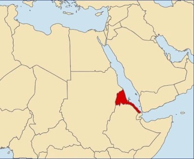
Location of Italian Eritrea.
Italian Eritrea is a first colony of the Kingdom of Italy. It was created in 1890 (but the first Italian settlements were done in 1882 around OTL Assab) and lasted officially until 1947. It is currently governed by Pietro Badoglio. Its area is 121,000 sq km (46,718 sq mi). In 1936, its population was approximately one million people. According to 1951 Census, there were 1,294,190 people living in Eritrea.
Since 1952, most of Afro populace is being killed by Italian colonists, but compared to all Italian African colonies, Italian Eritrea has most rights for Afro people, and most of them are allowed to emigrate to nearby British or French colonies.
The 1955 Census states, that population of Eritrea is 1,159,502, which is much smaller than it was according to 1951 Census.