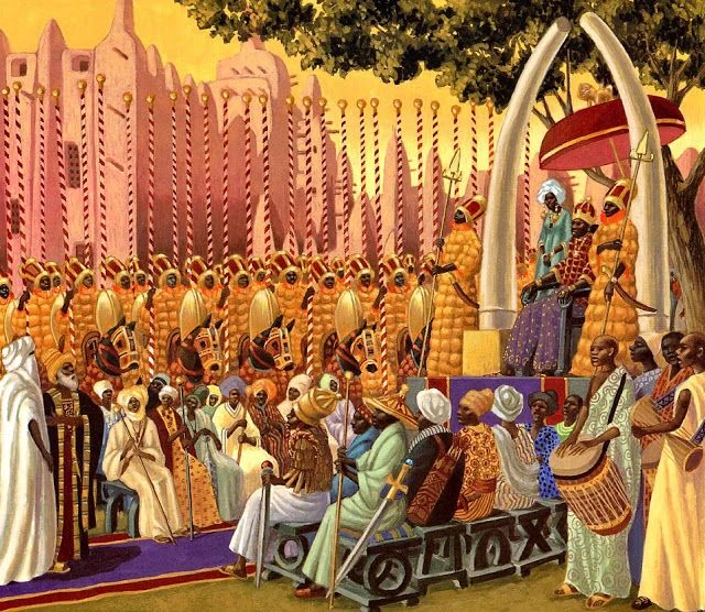
An envoy of Mansa Sulayman I arrives in New Timbuktu (1358)
During the Age of Discovery, a large-scale colonization of the two continents of Columbia and Muqaddas, involving a large number of empires, took place between around 1312 and 1800. The Norse had explored and colonized areas of Europe and the North Atlantic, colonizing Greenland and creating a settlement near the northern tip of Newfoundland circa 1000 CE. However, the later colonization by the European and African powers involving the continents is arguably more successful.
During this time, several empires from Europe, Africa, and Asia—primarily Córdoba, Castile, China, Portugal, England, France, Russia, the Netherlands, Denmark, Japan, Mali and Sweden began to explore and claim the land, natural resources and human capital of Columbia, resulting in the displacement, disestablishment, enslavement, and in many cases, genocide of the indigenous peoples, and the establishment of several settler colonial states. Some settler colonies—including Cosimoland, Alaska, the northern Great Plains, and the North-Western Territory in Columbia; the Isthmus of Tehuantepec, the Yucatán Peninsula, and the Darién Gap in Central Columbia; and the northwest Dhariba, the central Andes, and the Guianas in Muqaddas—remain relatively rural, sparsely populated, and Indigenous into the 21st century. Russia began colonizing the Pacific Northwest in the mid-18th century, seeking pelts for the fur trade. Many of the social structures—including religions, political boundaries, and linguae francae—which predominate in the Western Hemisphere in the 21st century, are the descendants of those that were established during this period.
The rapid rate at which the empires in Europe grew in wealth and power was unforeseeable in the early 15th century because it had been preoccupied with internal wars and it was slowly recovering from the loss of population caused by the Black Death. The Muslim domination of trade routes to Asia and the cape of Africa prompted Western European monarchs to search for alternatives, resulting in the voyage of Nuno Álvares Pereira of Portugal in 1386, via Malian routes, discovering the northern half of the continent that would later be named Columbia. Portugal, Burgundy, and Hungary were the only European powers to sail to the New World until the year 1497, which were followed by the arrivals of France and England, who were both focused on strife with one another and domestically. The nobilities of these countries did not see adventures across the Atlantic as profitable as a steady supply of goods from the Levant was temporarily able to enact economic rebound.
It quickly became clear to other Western European powers that they too could benefit from voyages west and by the 1530s, the English and French had begun colonizing the northeast tip of the New World. Within a century, the Swedish had established New Sweden, the Dutch had established New Netherland, and Denmark–Norway along with the other aforementioned powers had made several claims in the Sea of the King. In the 1600s, trans-Atlantic voyages undertaken by the Empire of Japan reached the modern coast of western Columbia, after having successfully colonized the Polynesian Island Chain. By the 1700s, Russia had begun to explore and claim the Pacific Coast from Alaska to Kosuto.
History[]
Norse settlement: 1000-1312[]

Statue of Leif Erikson, Straumfjörður, Vinland
Norse Viking explorers set foot on what is now Columbia in 1000. Norse journeys to Greenland and Canada are supported by historical and archaeological evidence. The Norsemen established a colony in Greenland in the late tenth century, and lasted until the late 17th century, with court and parliament assemblies (þing) taking place at Brattahlíð and a bishop located at Garðar. Norse explorer Leif Erikson established the colony of what is now Vinland around this point in time, and his brother is said to have had the first contact with the native population of Columbia which would come to be known as the skrælings. After capturing and killing eight of the natives, they were attacked at their beached ships, which they defended.
The Norse colonies had a relatively mixed economy, and the demographics of the region have suggested interaction between the settlers and the native Inuits. Largely, it has been suggested that the colony stayed in obscurity due to the belief of the local population that the landmass to the north (modern-day Canada), was connected to Greenland through the Northwest Passage, thus eroding a need to call upon other European powers for aid if it were to fall or collapse. Under the Kalmar Union, the longevity of the distance between Scandinavia and Vinland meant that the latter had developed a distinct identity.
Arrival of Mali: 1312-1386[]
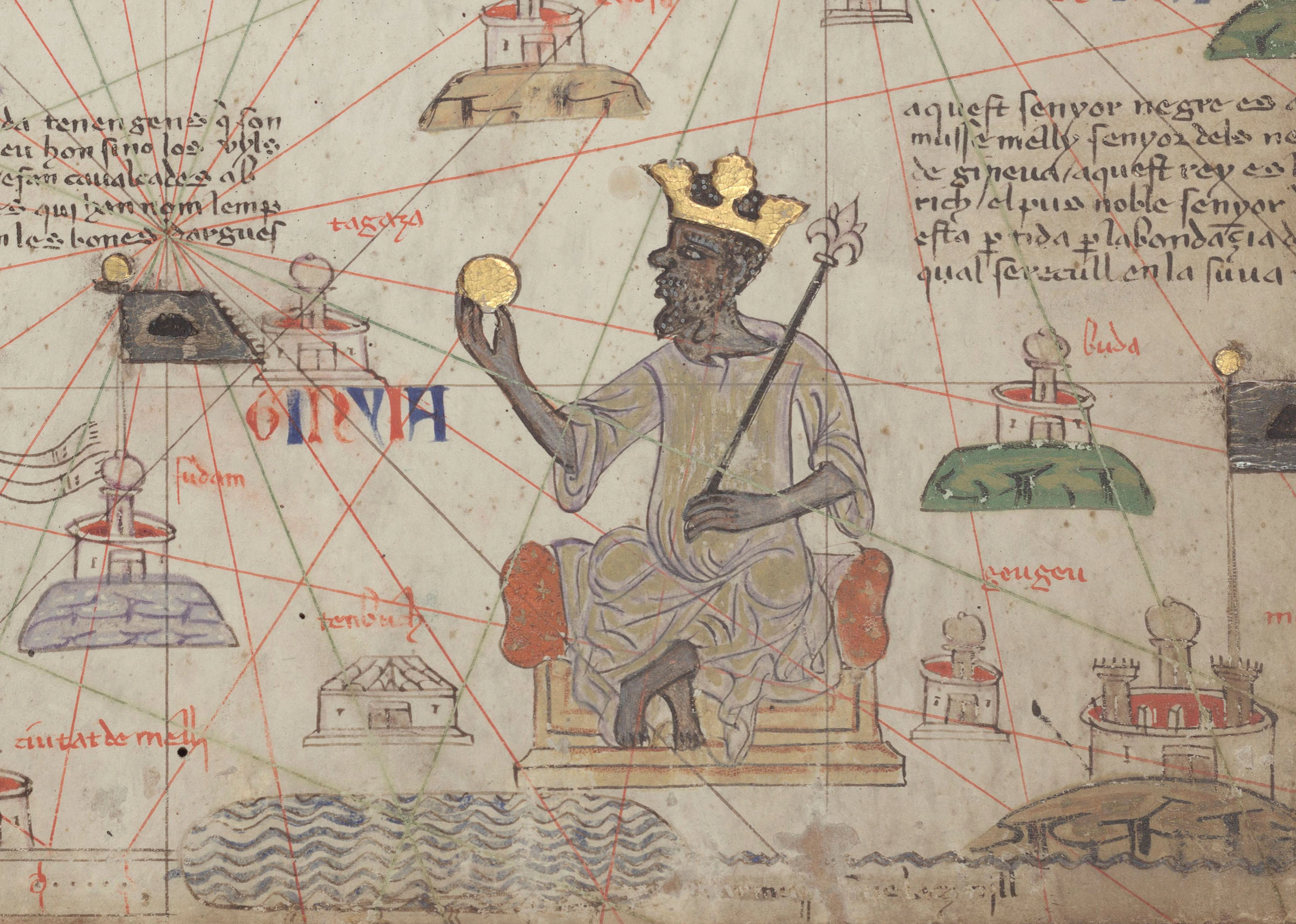
Despite conflicting evidence as to whether or not it was a Mansa, or an explorer who sailed on behalf of him, Mali under Muhammad ibn Qu made arrival in what is now Al-Bayd in 1312. The goal was to potentially sail across the Atlantic Ocean to find a land of interest, or to circumnavigate the globe with the goal of subduing beliefs by their northern counterparts that Mali's seeming decadence and vast riches would bring about a decline. Their voyage was accounted by Mansa Musa, Qu's successor, in 1324 while on hajj in Arabia, which described the provisions made before the arrival:
Mansa Musa, ninth Mansa of the Mali Empire, actively began funding expeditions across the Atlantic after the voyage of his predecessor.
| “ | We belong to a house which hands on the kingship by inheritance. The king who was my predecessor did not believe that it was impossible to discover the furthest limit of the Atlantic Ocean and wished vehemently to do so. So he equipped 200 ships filled with men and the same number equipped with gold, water, and provisions enough to last them for years, and said to the man deputed to lead them: "Do not return until you reach the end of it or your provisions and water give out."
They departed and a long time passed before anyone came back. Then on a day in summer several ships returned and we asked the headmaster what news they brought. He said: "Yes, O Sultan, we traveled for a long time until there appeared in the open sea as it were a river with a powerful current. All ships had been directed by third captain of the main fleet to follow it. A dozen ships did not survive the voyage, but we soon came upon a large landmass which had an unforeseen abundance of fritillaries and an admixture similar to that of the land to our own south." It was now believed that there indeed existed a land where the proclaimed abundance was many, and based upon these routes many of our richest men sailed eastward, though it was said that this man's address had formally misconceived the route in a manner to seem more promising towards such a venture, perhaps to encourage it, or conversely to send the richest men to their deaths in this current, as the Mansa was absent at the time of the headmaster's arrival. |
” |
–Mansa Musa, 1324 | ||
At the time of Mansa Musa's ascension to the throne, Mali in large part consisted of the territory of the former Ghana Empire, which Mali had conquered. Musa went on hajj to Mecca in 1324, traveling with an enormous entourage and a vast supply of gold. En route, he spent time in Cairo, where his lavish gift-giving is said to have noticeably affected the value of gold in Egypt and garnered the attention of the wider Muslim world. Musa expanded the borders of the Mali Empire, in particular incorporating the cities of Gao and Timbuktu into its territory. He sought closer ties with the rest of the Muslim world, particularly the Mamluk and Marinid Sultanates, as well as Cordoba. He recruited scholars from the wider Muslim world to travel to Mali, such as the Andalusian poet Abu Ishaq al-Sahili, and helped establish Timbuktu as a center of Islamic learning. His reign is associated with numerous construction projects, including part of Djinguereber Mosque in Timbuktu.


A map outlining colonies and claims by the Mali Empire, circa 1400
While initially uninterested in the prospects of a transatlantic voyage, Musa did not prohibit ships of his own accord moving back and forth between the hypothesized land, and allowed explorers such as Ibin al-Qua to use resources to establish settlements in the region. With the aid of their Cordoban counterparts, Mali invented the Windward Vessel, a ship whose lateen sails gave it speed and the capacity for sailing windward (beating). New Timbuktu was founded in 1330, and became the first colony to financially thrive in the New World. After discovering the length of the landmass outside of the settlement, Moroccan explorer Ibn Battuta while sailing for Mali hypothesized the existence of a new continent. Upon arriving back in Mali in 1357, Battuta illustrated his findings and named the continent "Muqaddas", meaning "sacred" or "holy". His findings were followed by Mansa Sulayman I and an envoy visiting the colony a year later.
The Mali Empire, at home and abroad, expanded through conquest or annexation. In the event of conquest, farins took control of the area until a suitable native ruler could be found. After the loyalty or at least the capitulation of an area was assured, it was allowed to select its own dyamani-tigui. This process was essential to keep non-Manding subjects loyal to the Manding elites that ruled them. In the New World, a lack of major resistance on behalf of the natives meant that farins often had indefinite rule. It was not until the 1500s that the first native ruler was elected to regional office in Al-Bayd. Barring any other difficulties, the dyamani-tigui would run the province by himself collecting taxes and procuring armies from the tribes under his command. However, territories that were crucial to trade or subject to revolt would receive a farba. Farbas were picked by the mansa from the conquering farin or family members. The only real requirement was that the mansa knew he could trust this individual to safeguard imperial interests.
While little records do exist of the early interaction between the natives and the Malian settlers, several have referred to them as the "lesserspeakers", likely a name given due to the inability of Malian explorers to actively communicate. Enslavement of the natives took place from a period lasting from 1320 to 1450, and while Malian contact granted surviving natives immunity from later European diseases, many were assimilated into the later Afromuqaddian culture that has lasted into the modern day. News of the colonies did not reach Europe until around the 1350s, and most nations did not actively view it a concern due to Battuta's label of the region as a continent not being widely accepted in Mali proper until shortly after Portugal had made landfall. Mass conversions of the natives to Islam also established a religious foothold, extending the Christo-Islamic conflict from its origins in the Levant to the New World.

The Mansa's Arrival in the Canopy, 1879, Claude Monet
Several post-caliphates emerged in Muqaddas around 1360, with the Tupi having organized a Mali-aligned coalition of their own that lasted for two decades and inhabited an area housing the natives who had developed immunity to the diseases brought by trade. It is entirely possible that Malian contact resulted in disease spreading rapidly westward, southward, and northward into Columbia as both Aztec, Cuzco, and Chimor texts recall a "great pestilence", "disturbed sickness", and "malevolent trough" spreading into their lands during the presumed late 14th centuries. By 1370, the Marinid Sultanate had managed to bargain several models of Mali's Windward Vessel, and Sultan Abu al-Abbas Ahmad al-Mustansir sent an expedition of around 13,000 men to make landfall in the region. They landed in what would eventually become Suriname, and named the land Buluringo, a Mandinka word, in order to prevent competition over the new territories. Despite efforts to prevent competition, there are records from both the Marinids and Mali which show that both groups did trade blows over competing for the allegiances of various indigenous peoples in the region, specifically the Arawaks.
Other evidence has suggested that Mali's initial expedition had managed to reach the Sea of the King. According to the Castilian navigator Bartolomé de las Casas, the purpose of Christopher Columbus's third voyage was to test both the claims of King John II of Portugal that "canoes had been found which set out from the coast of Guinea [West Africa] and sailed to the west with merchandise" as well as the claims of the native inhabitants of the Sea of the King island of Hispaniola that "from the south and the southeast had come black people whose spears were made of a metal called guanín ... from which it was found that of 32 parts: 18 were gold, 6 were silver, and 8 copper. Malian records additionally state the existence of a "northern land that was known as Banyi-fay", a word that roughly translates to "Island of Greenery" in English, likely referring to the island itself.
The first European navigator to seriously propose the existence of a major continent having been discovered by the Islamic world was the Portuguese nautical explorer Afonso Nunez, who wrote in 1352 that "to the south exists a fluctuation of trade that, by circumnavigation of an ulterior landmass, is far larger than any kind of isle", noting the pattern of movement held by Malian vessels which had been accredited to a lack of interest in conducting the Canary Current. His observations are supported by a similar report by Afonso IV in a manuscript describing the trades conducted by the Marinid Sultanate. By 1380, nearly 70 years after Mali had made landfall, Europe became aware of the prospects and actual size of the New World.


Nuno Álvares Pereira of Portugal was the first European to land in the New World, in 1386
Chinese, Portuguese, Hungarian, and Burgundian entrance: 1386-1492[]
With its threats to the north neutralized and the Song's borders and economy expanding rapidly, the Song renaissance continued well into the 15th century. The ascension of Gaozong to the position of Emperor marked a turning point in the Song dynasty's history. During the reign of Gaozong, Zheng He began his voyages westward to make contact with the polities of the Indian Ocean and east Africa to expand China's trading network. At the same time, explorer Hong Bao was sent eastward deep into the Pacific Ocean to search for islands that China could trade with. Hong Bao would make contact with the Tuʻi Tonga Empire, the Hawaiian Islands, and eventually made landfall in southern Columbia on 15 June 1417, resulting in China reaching the New World 96 years after the initial Malian voyage. Soon, the Chinese name for the Columbian continent became Meiguo (美国) meaning "beautiful country." With new trade routes discovered, China soon established tributaries over the Hawaiian polities and the Boluka Kingdom in Meiguo. Chinese settlers, primarily merchants, scholar-officials, and peasants, also began migrating to Meiguo and Hawaii with the goal of amassing fortune for themselves.
Nuno Álvares Pereira of Portugal was the first European explorer to make landfall in the New World, though his expeditions reached Columbia and not Muqaddas where the Islamic world had settled. His family had a maritime background, and one of his ancestors, Diogo Pereira, surveyed the North African coast in the 1340s and issued pamphlets detailing its riches. Tracing his biography is complicated by the existence of several contemporary Portuguese seafarers with the same name. He was clearly a seaman of considerable experience and may have been trading for ivory along the Guinea coast as early as 1378. That same year, Pereira, aware of the Malian trade systems in the South, was hired by John I of Portugal to "travel to the farthest extent of the Atlantic Ocean" as had been done by Mali. In October, Pereira set sail from Coimbra and traveled for around five weeks in a Mali-inspired vessel that the Portuguese called the "Caravel". He recorded his findings on 1 November 1386, and briefly had a group of cartographers map the coastline of what would later be known as New Brunswick.
Pereira's crew landed in a territory they named Estranhoia, which became the first major settlement of Portugal in the New World. According to several historians, their main focus was rather to prove to the Christian world that another continent at the far end of the Atlantic existed, rather than having to establish a permanent settlement. The dynamic timber trade became active by 1380, and Portugal soon began to profit after several coastal outposts in the Sea of the King, which lasted until the mid-16th century, produced sugarcane and dye for their own use. The Portuguese never gave the new continent a name, and the name "New World" was not widely used until 1500. Pereira, converse to the beliefs of other explorers, believed that he had landed in a subcontinent near Africa, and referred to the natives as lightskins, due to their genetic similarities to their Malian counterparts.
The sudden rush for timber and, following its discovery in a reservoir in the modern island of Nassau, considerably increased the revenue of the Portuguese crown, who charged a fifth of all the ore mined, or the "fifth". Diversion and smuggling were frequent, along with altercations between native residents and Emboabas (immigrants from Portugal), so a whole set of bureaucratic controls began in 1410 with the captaincy of Estranhoia and Hybrasil. By 1418, Estranhoia and Hybrasil became two captaincies, with eight vilas created in the latter. The crown also restricted the diamond mining within its jurisdiction and to private contractors. In spite of gold galvanizing global trade, the plantation industry became the leading export for Portuguese colonies during this period; sugar constituted at 50% of the exports (with gold at 46%) in 1425. Portugal and Mali often disputed with one another over the natural resources of the Sea of the King, but avoided direct military endeavors due to internal conflicts. The first map of "the lands across the Atlantic perseverence" were published anonymously in Portugal in 1420, and subsequently were used by both Malian and Portuguese explorers as a means to establish properties in these areas.


Territories of the continent of Columbia, 1450
Following several failed attempts caused by extreme currents, the Principality of Hungary, using trade agreements with the Marinid Sultanate and Cordoba, launched their own expedition to the New World in 1429 under the cartographer Mészáros Flórián, who established a port in modern San Esteban, which he named Kékszél. Upon Flórián's arrival and success, fifteen latitudinal tracts, theoretically to span from the coast to the Portugal-Mali limit, were decreed in December 1434. Afterwards, the Hungarian colonists established a system similar to the later Castilian encomienda, which focused on enslavement of native peoples, usually the Taino, to produce manual labor, as direct purchases of Malian-born slaves for diplomatic purposes at that time was considered unaffordable. Szent István became a hub for trade, though the Portuguese seldom used the port for purposes outside of economic negotiation.
From 28 August 1446, slave trade as practiced with natives was included in a royal letter and on 12 March 1445 the taxation regime for the shipment of Arawak slaves was established. Between a third to half of Szent István's population were registered slaves in 1449 (estimations are between 1,283 and 2,033 slaves). In 1450, the Hungarian Atlantic Company was established on the island with responsibility for maintaining the port and the employment of Hungarian officials. By the end of the century, around 245 ships visited the port of Szent István annually. Burgundian nobles under the orders of Charles the Bold were additionally enticed to set up colonies along the northern Antilles, which became hubs for shipping but not outright settleents until around 1460. Regardless, the first Burgundian settlement became the city of Vieville, in 1463. In 1478, using newfound compasses, the Portuguese explorer Bartolomeu Dias attained funds from his local compact in the Sea of the King to create a settlement far more north, naming it Lavradoria.
Columbian era: 1492-1600[]


Columbus in the Gulf of Ophir, 1601, unknown artist
In 1492, Christopher Columbus sailed on behalf of Tuscany and Castile and make landfall in the Sea of the King, where he greatly exaggerated the abundance of the land and coined the term "Terra Nova", a Latin translation of the term for the continents. Eventually, the northern half of the New World, Columbia, would be named for him. Five years later, in 1497, the possibly Genoese explorer John Cabot, commissioned by Henry VII of England, took a group of three ships headed by the Matthew of Bristol to find a trade route to Asia. They stumbled upon the landmass that would eventually become the modern nation of Canada. Cabot's logs, from 1497 and 1498, both state that the expedition made no contact with any native people; the crew found the remains of a fire, a human trail, nets, and a wooden tool. The crew appeared to have remained on land just long enough to take on fresh water; they also raised the Venetian and Papal banners, claiming the land for the King of England and recognising the religious authority of the Roman Catholic Church. After this landing, Cabot spent some weeks "discovering the coast", with most "discovered after turning back". They returned in 1499, and set up the first English colony in the New World, which they called Cardiff, after the Welsh capital city of the same name. That same year, an Irish expedition sailing for England established the port city of Talamh Báistí, meaning "land of rain".
Conflicts between Mali and the incoming Europeans resulted in the Pilgrim Crusades of 1504-1536, in which religious chivalries clashed with the authorities of Islamic-based colonies throughout the New World, but largely in Muqaddas. While the Malian territories successfully defended themselves, the Marinid colonies were relatively vulnerable and were captured by the English in 1523. However, instability from Malian-funded native raids led to the English abandoning the colony soon afterwards, allowing Hungary, Courland, and Irish expeditionaries to begin exploring it en masse. Paltry returns had at large been minimal from the European territories until this point, hence why the colonization of the New World is split into two eras - the Bakarian and the Columbian. While the native tribes in Muqaddas and central Columbia proved to be immune to European diseases, the majority of the states in Columbia proper were not, and the Mississippian empires, which had dominated the wheat trade in the Gulf of Ophir since the 1300s, collapsed following contact with French traders. Similarly, massacres against Taino natives by French occupiers have been recorded to have occurred in the 1530s, though the worst examples of European genocide were often done at the hands of Hungary.
A Castilian effort to capitulate Mexica, then known as the Aztec Empire, in 1522 ended in failure, in part due to the inability to commit significant forces due to consistent land disputes between varying European powers. Despite this, Cordoba launched a successful expedition to take control of Castilian territory in what is now Isla de Mahoma. Afterwards, Cordoba set up a trade network that allowed them to interact with Mexica. Marking a new precedent for interactions between indigenous and colonial states, Mexica and Cordoba entered into a personal union following the marriage of Ahmed I to Isabel Moctezuma. Already exhausted from the Crusades, European powers made only a limited effort to prevent Cordoba from converting the nation to Islam. Cordoba proved willing to make alliances with indigenous powers, but often strongarmed them with the threat of enslavement or outright conquest. Deposits of silver allowed Cordoba to become the most profitable power in the New World after Mali by the mid 1500s.
From 1548, English settlers began moving southwards from the wooded territories in modern New England. The Popham colonies proved profitable, and an export of leather, fur, and other dynamic materials greatly increased the area's commercial economy. A charter system was established by the English crown that same year, though forbearance of legal rights emerged as a primary issue. Palisades were often used as fortifications to fend against the issue of Susquehannock raids onto the early colonies near Boston. Thomas Seymour, 1st Baron Seymour of Sudeley, after fleeing England in 1549, set up the colony of Sudeley in modern Frisland, giving the area its name. The mass colonization of the eastern coast of Columbia by the English began with the establishment of the Hawkins Territory in 1567 and the Pilgrims' colony at Plymouth in 1620. In 1619, Virginia's House of Burgesses became the first elected legislative assembly on the continent. Harvard College, founded in 1636 in the Massachusetts Bay Colony, marked the establishment of the first institution of higher education. The Mayflower Compact and the Fundamental Orders of Connecticut set the stage for representative self-government and constitutionalism, which would shape the development of the Columbian colonies. Many English settlers, driven by a desire for religious freedom, were dissenting Christians.
| ||||||||||||||