Banat Flag
Republic of Banat
The Republic of Banat (Romanian: "Republica Bănățeană", German: "Bundesrepublik Banat", Serbian: "Bantska Republika/ Банатска република", Hungarian: "Banati Koztarsasag", Italian "Republica Banato", French "Republique de Banato" ) is a federal republic. The country is situated in the central Europe, where it is bordered with Hungary to the North, Transylvania to the East, Romania to the South-East, Serbja and Bulgaria to the South and Croatia to the West.
Banat has a long history of neutrality from the ancient Middle Ages.
1. Origins:
In the 9th century, at the end of Roman Empire, the Romans maintained on the west side the little province Dacia. After Roman Emperor Traian conquered Dacia in 105-106, the province of Dacia contained all the territory between the actual river Prut, Danube, Tisza and the all Carpathian Mountains. During that time, because the barbarians conquered a big part of Dacia, the Roman province was reduced to the land between the Carpathian Mountains and the River Tisza, Danube and Sava.

Gesta Hungarorum Map
The year 896 represents the end of Roman administration of Dacia. During the winter between 896 and 897 Huns and Slavs tried to conquer the ancient Roman region of Dacia, but it was impossible. The people from Roman municipalities of Sarmizegetusa Regia, Tibiscum, Drobetense, Zambara, Partiscum and many other important municipalities take the decision to create the Kingdom of Banat, in the spring of 897. This spring is called "Banatus Ver" (the spring of Banat). At the beginning, the kingdom contains only the territory between the river Strei at east, the river Maros at north, the river Tisza at west and the Danube at South. The first king of Banat was "Glad the First". The term of Banat is coming from the name of the last Roman governor of Dacia province "Banus". At that time in Banat was a mixture of population:
- Romanians or Daco-Romans.
- Magyar.
- Bulgarians.
- Gothi (German people).
Over the time Banat was extended from the little province to the actual territory with the natural borders of :
- the River Danube at East.
- the River Sava, Moravia and Timok at South.
- the River Danube and the Carpathians Mountains at South-East.
- the small rivers of Jiu, Strei and the Carpathians Mountains at East.
- the River Fekete-Koros (White Koros) at North.
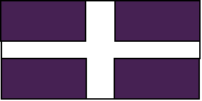
The flag of Banat is adopted in the year 1345. The cross is the symbol of Christianity and also is a symbol of the four main rivers of Banat: Danube, Sava, Tisza and Maros. The purple is the symbol of the Roman flame in the eastern part of Europe and all the wars to defense with dignity the Latinity and the peace.
2. Banat - a multicultural Federal Republik
Banat has three major populations: Romanian (25%), German (20%), Serbs and Croats (17%) and Magyar (16%). Other important populations are: Italians (8%), French (5%), Czech and Slovaks (4%), Bulgarians (3%), Ukrainians (0.5%) and Polish (0.5%). From the ethical point of view, Banat is a "Little Europe" with Latin, Slavic and German population. All the people from Banat are Christians (Orthodox or Catholics), and from the National Law of Young Glad (Glad V or "Glad Tânărul") there is not allowed Jews or Muslims to immigrate into Banat.
The Banat Confederation consists of eight forms of administration: "voievodat" for Romanian local administration, "canton" for Germans, "banovina" for Serbians, "zupanja" for Croats, "megye" for Magyars, "regione" for Italians, "le departement" for the French and "oblasti" for Bulgarians. Each type of local administration has a specific structure from the legi.
The local governments of Banat Confederation are:
- Metropolitan Administration of Temeschburg (district of Banat Confederation Capital).
- Voievodatul Lipova(ro)
- Voievodatul Lugoj (ro).
- Voievodatul Nădragului (ro).
- Voievodatul Făgetului (ro).
- Voievodatul Ineului (ro).
- Voievodatul Buteniului (ro).
- Voievodatul Brad (ro).
- Voievodatul Abrudului (ro, pl).
- Voievodatul Hunedoara(ro).
- Voievodatul Hategului (ro).
- Voievodatul Sarmisegetuza Regia (ro).
- Voievodatul Jiului (ro,pl,cz,sk).
- Voievodatul Motrului (ro,pl,cz,sk).
- Voievodatul Drobetes (ro).
- Municipality of Orschowa.
- Voievodatul Maidanului (ro). [Majdanpek]
- Voievodatul Cladovei (ro). [Cladova]
- Voievodatul Crainei Negotinului(ro)
- Voievodatul Bor (ro).
- Voievodatul Zăiceari (ro).
- Voievodatul Timocului Alb (ro). [Timacum Maius / Knjazevac]
- Voievodatul Șoimești (ro). [Sokobanja]
- Voievodatul Boljevac (ro).
- Voievodatul Homoliei (ro).
- Voievodatul Gradistei Mari (ro/serb) [Gradistea Mare / Veliko Gradiste]
- Voievodatul Golubățului (ro/serb) [Golubac]
- Voievodatul Piatra Mlavei (ro/serb). [Petrovac]
- Voievodatul Jăgobiței (rom/serb). [Zagubica]
- Voievodatul Cuciovei (rom/serb). [Kucevo]
- Voievodatul Moravei (rom/srb). [ includes Svilaina(Svilajnac), Zabari]
- Voievodatul Baciului (rom/srb-croat). [Bac]
- Voievodatul Seleusului (rom/srb/germ).
- Cenad Canton
- Canton Reshitza.
- Klein-Schlatten Canton (ge).
- Passarowitz Canton (ge/rom). [ Passarowitz / Podu Lung / Pozarevac]
- Theisshugel Canton (germ/serb).
- Karlowitz Canton (germ/serb/polish/magyar).
- Josefdorf Canton (germ/croat). [Josefdorf/Zabalj]
- Thomasberg Canton (germ/croat). [Thomasberg / Sveti Tomo]
- Plakenburg Canton (germ/croat). [Plakenburg / Backa Palanka]
- Hodschag Canton (germ/hu/serb). [Odzaci]
- Wolfsburg Canton (germ/hu/serb). [Kula]
- Gross Kikinda Canton.
- Neu-Kanischa Canton.
- Tschoka Canton.
- Neu-Betsche Canton.
- Sankt Georgen an der Bega Canton.
- Petersheim Canton.
- Metropolitan Administration of Gross Betschkerek.
- Zichydorf Canton.
- Opowa Canton.
- Werschetz Canton.
- Weiss Kirchen Canton (germ/rom).
- Metropolitan Administration of Panschowa-Kevevara.
- Regione de San Pietro
- Regione de Nova
- Regione de Drobeta
- Csongrad Megye (
- Deva Megye (hu).
- Piskitelep Megye (hu).
- Algyogy Megye (hu).
- Obecse Megye (hu/serb). [Olbecse / Becej]
- Zombor Megye.
- Szabadka Megye (hu/croat). [Subotica]
- Topolya Megye (hu/croat). [Backa Topola]
- Kishegyes Megye (hu/croat). [Mali Idos]
- Ada Megye (hu/germ).
- Zenta Megye (hu/germ).
- Magyarkanizsa Megye (hu/germ).
- Smederevo Banovina (serb/rom). [Smederevo]
- Malo Crnice Banovina (serb/rom).
- Zabari Banovina. (serb/rom).
- Cuprija Banovina (serb / rom).
- Paracin Banovina (serb/rom).
- Despotovac Banovina (serb/rom).
- Alexinatz Banovina (serb/germ).
- Razanj Banovina (serb).
- Svrljig Banovina (serb).
- Sremska Mitrovica Banovina (serb).
- Pecinci Banovina (serb).
- Stara Pazova Banovina (serb).
- Ruma Banovina (serb).
- Indija Banovina (serb).
- Irig Banovina (serb).
- Metropolitan Administration of Novi Sad (Neusatz / Ujvidek)
- Vrbas Banovina (serb/germ).
- Beocin Banovina.
- Tabakovac Oblasti (bulgarians).
- Temerin Zupanja (croats/germ).
- Sid Zupanja (croats).
- Jablanita Zupanja (croats).
- Le departement du Lovrin (French). This "departement" is an enclave in the German canton of Cenad, with French administration.
- Le departement du Moulin (French).
- Backy Petrovec Voievodat (Slovak/Serb).
- Apatin Voievodat (Sokci/Magyar/Croat).
- Kovacica Voievodat (Slovak/Serb).
In Banat is a direct democracy. There are three levels of administration: the local government level, the national level and the federal level. The local government is represented by the local communities. The main regional capitals are:
- Hunedoara, is the city where is located the Latin Parliament. The Latin Parliament represents the Romanians, the Italians and the French population. The Latin population is approximately 38% of the entire Banat population.
- The Magyar Parliament is located in Bekeschaba.
- At Gross Becicherec is located the German Parliament.
- Novi Sad (Neu Satz) is the city where the Slavic Parliament is which represents the Serbs and Croats, the Czech and Slovaks, the Bulgarians, Ukrainians, and Polish people (approximately 25%).
3. Industry
4. Transports
In Banat there are several highways, between the main important cities and industrial:
- A1. Temeschburg - Steierdorf - Moldova Noua - Piatra Mlavei - Zabari - Alexinatz - Zăiceari - Vidin with directions to Sofia (Bulgaria), Skopje (Macedonia), Nis (Serbia) and Thesalonik (Greece).
- A2. Temeschburg - Gross Bectschkerek - Novi Sad - Sremska Mitrovica with directions to Zagreb (Croatia), Ljublijana (Slovenia) and Venezia (Italy).
- A3. Temeschburg - Ciacova - Zichidorf - Opowa - Beograd.
- A4. Temeschburg - Buziaș - Bocșa - Reshitz - Werschetz with two variations: A4.1 Weiss Kirchen and A4.2 Panschowa - Kevevara. A4.3 : Werschetz - Oravița - Weiss Kirchen. A4.4 Oravița - Steierdorf.
- A5: Temeschburg - Lugoj - Ilia - Deva - Piskitelep - Algyogy. A5.1 Ilia - Pojoga.
- A6: Temeschburg - Lugoj - Karansebesch - Jablanita - Mehadia - Herculaneum - Orschowa - Drobeta. A6.1: Karansebesch - Reshitz. A6.2 Karansebesch - Sarmisegetusa Regia - Hațeg.
- A7: Temeschburg - Lippa - Bârzava - Săvârșin - Pojoga - Brad - Abrud - Câmpeni - Baia de Arieș. A7.1 Brad - Deva. A7.2 Lippa - Arad - Szeged - Baja.
- A8. Temeschburg - Cenad - Szeged - Keksemet with directions to Budapest (Magyarorszag), Bratislava (Slovakia) and Wien (Austria).
- A9. Temeschburg - Arad - Zimand - Salonta with directions to Oradea (Romania), Debrecen, etc. A9.1 Zimand -
- A10. Vidin - Negotin - Maidan - Golubăț - Moldova Noua - Weiss Kirchen - Pantschowa/Kevevara - Novi Sad - Apatin - Homorud - Baja - Kalocsa - Solt with directions to Budapest (Magyarorszag), Bratislava (Slovakia) and Wien (Austria). A10a: Negotin - Drobeta - Orschowa- Herculaneum - Mehadia - Bozovics- Stancilova - Moldova Noua. A10b: Bozovics- Steierdorf.
- A11. Novi Sad - Backi Petrovec - Zenta - Szeged - Bekeschaba-Keksemet with directions to Debrecen (Magyarorszag) - Miskolc (Magyarorszag) - Kosice (Slovakia) - Krakow (Poland).
- A12. Deva - Hunedoara - Hațeg - San Pietro - Jiu - Motru - Drobetes - Cladova - Negotin - Vidin with directions to Sofia (Bulgaria), Istanbul (Turkey) and Thesaloniki (Greece).
The main navigable rivers:
- Danube
- Tisza.
- Sava.
- Maros from Algyogy to Tisza.
- Morava from Cuprija to Danube.
- Bega Canal.