|
|
| |
|
Africa · Antarctica · Asia · Australia and the Pacific · Europe · North America · South America |
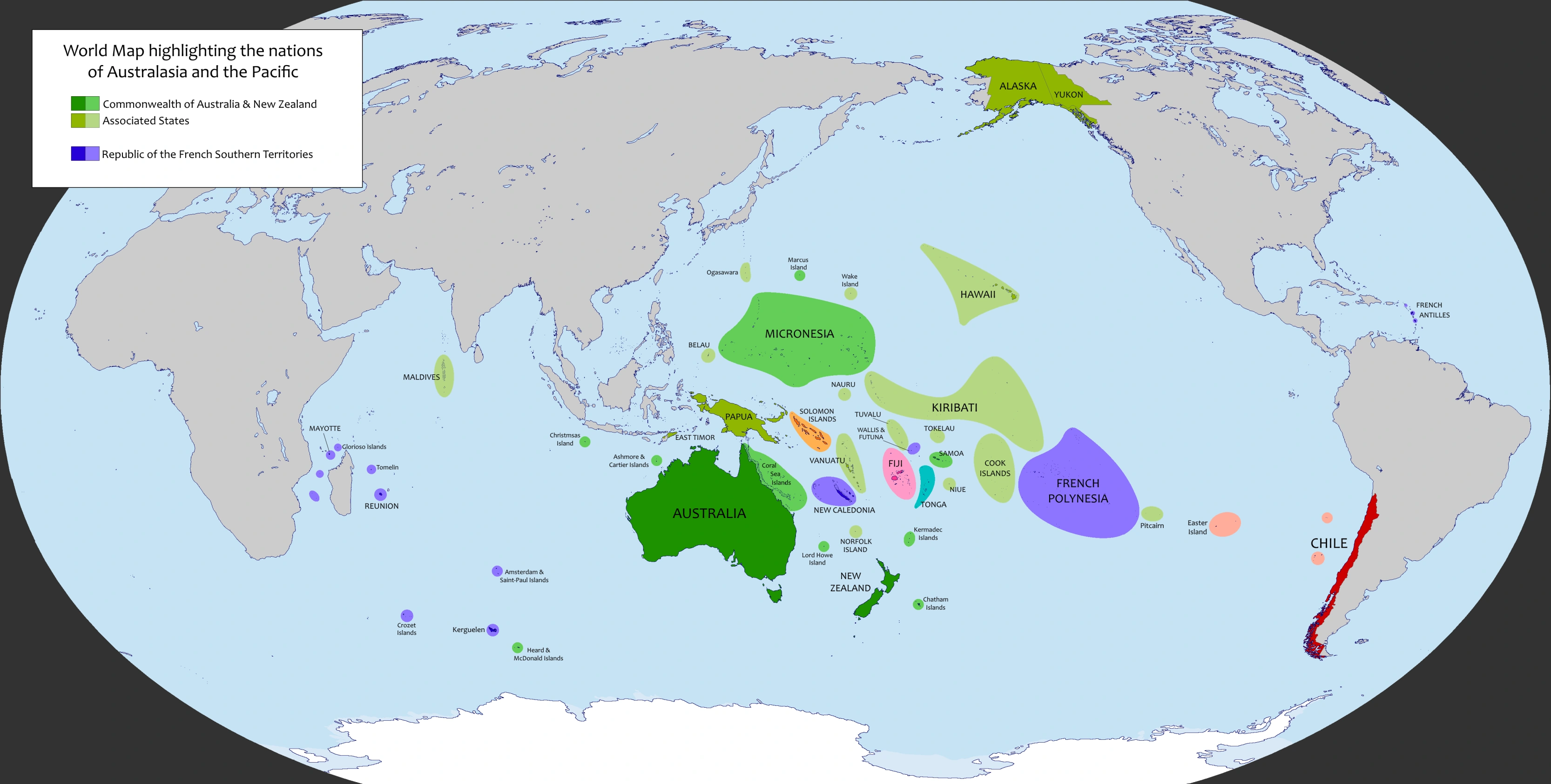
The regions of Australia, New Zealand, the three subregions of Melanesia, Micronesia, Polynesia, are the far flung islands of the Pacific are commonly referred to as Oceania or Oceanica. On September 26, 1983, the region suffered a fair amount of nuclear strikes of Soviet origin due to its presence of U.S. military installations. The strikes included the cities of Perth, Melbourne, and Sydney in Australia, several military installations and the capital of Honolulu in the State of Hawaii, and the islands of Guam, Wake, Kwajalein, and Johnston - all which were strategic bases for U.S. forces in the Pacific. However, majority of the island nations were not targeted by Soviet missiles during Doomsday, so these island nations resorted to old customs of fishing and communication with nearby islands which greatly aided the survival of these nations. Other formed unions such as the Commonwealth of Australia and New Zealand, in which other island nations joined the commonwealth or are free associated states. The ANZC is considered one of the world's superpowers after Doomsday.
List of Australia and Pacific Survivor States
List of Former Sovereign States
| Flag | Location | Name | Capital | Area | Population | Predecessor | Status |
|---|---|---|---|---|---|---|---|
| Mirconesia |
Republic of Belau |
Koror | 459 km² | 14000 |
Belau |
Associated State of CANZ | |
| Soloman Islands | Bouganville & Soloman Islands | Arawa | 37784 km² | 687,000 |
Bouganville Soloman Islands |
Independent Nations | |
| South Pacific |
Cook Islands Kūki 'Āirani |
Avarua | 240,000km² | Cook Islands | Associated State of CANZ (specifically NZ) | ||
| Australasia | Commonwealth of Australia and New Zealand | Jervis Bay | 7.889.286 km² | 28,796,705 | Australia | Association of states | |
| South Pacific |
Republic of the Fiji Islands |
Suva | 18.274 km2 | 840,000 | Fiji | Independent State | |
| Oceania |
Free State of Hawaii |
Hilo | 19523 km² | 82,600 | Hawaii, United Statates | Associated State of CANZ | |
| Pacific |
Republic of Kiribati |
South Tarawa | 726 km² | 98,000 | Kiribati | Independent State | |
| Micronesia |
Nauru Republlic of Nauru |
Yaren | 21 km² | 10,000 | Nauru | Associated State of CANZ | |
| Niue |
Niuē Fekai |
Alofi | 260 km² | 1398 | Niue | Associated State of CANZ | |
| Oceania |
Independent State of Papua New Guinea |
Port Moresby | 786,000 km² | 7500,000 |
Papua, New Guinea, West Guinea (Indonesia) |
Associated State of CANZ | |
| Pacific (South) | Pitcairn Islands | Adamstown | 447 km² | 75 | Pitcairn Islands (British Overseas Territory) | Associated State of CANZ | |
| Pacific | Republic of the French Southern Territories | Papeete | 36.297 km² | 3,000,000 | Collection of French Territories | Former Overseas Countries of France | |
| Pacific | Tokelau |
none |
11.5 km² | 1,453 | Tokelau | External Territory of CANZ | |
| Pacific |
Kingdom of Tonga |
Nuku'alofa | 748 km² | 112,000 | Tonga | Independent State | |
| Pacific | Tuvalu | Funafuti | 26 km² | 12373 | Tuvalu | Assosiated State of CANZ | |
| Pacific | Vanuatu | Port Vila | 12200 km² | 200,000 | Vanuatu | Independent State |
")
")